

 Facebook
 X
X
 Pinterest
 Copy Link
Douglas Lake Overview
Where is Douglas Lake located?
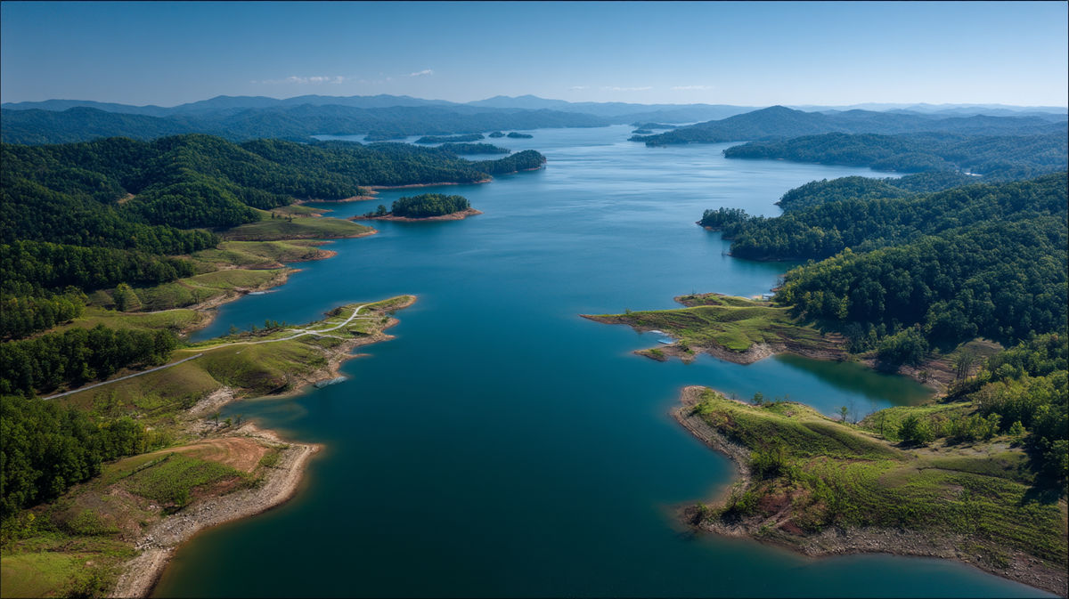
Douglas Lake in Tennessee sits in East Tennessee’s rolling foothills just west of the Great Smoky Mountains, stretching 60 miles along the French Broad River before that river joins the Holston to form the Tennessee River.
The 30,400-acre Douglas Reservoir’s serpentine shoreline winds past camp sites, picnic spots, and small towns that market themselves as a laid-back destination for visitors chasing sunrise views over blue water and green ridges.
Why was Douglas Lake created?
The Tennessee Valley Authority built Douglas Dam in 1942, at World War II speed, to produce hydropower, curb downstream flooding, and keep an eight-foot navigation channel open for barge traffic on the Tennessee River.
Four generating units inside the hydroelectric facility still turn runoff into electricity every day, proving that the control system first envisioned for flood storage and overall water control still pulls its weight in the current day.
Douglas Lake Recreational Activities
Because the lake level rises high enough each spring to flood coves and backwater sloughs, anglers rave about striped bass and crappie fishing.
Summer brings a flotilla of boats-everything from kayaks to wake-surf rigs-plus shoreline Recreation staples like camp grills, beach chairs, and quick picnic breaks between swims.
It’s no surprise that two million visitor days are recorded here annually, with Douglas Lake water level forecasts guiding every boat launch.
Why Do Douglas Lake Water Levels Fluctuate?
Seasonal Patterns Explained (Spring vs. Summer vs. Winter)
Tennessee Valley Authority (TVA) targets a summer pool of roughly 990 feet above sea level, then lets the water rise a few extra feet in late spring when precipitation and snowmelt out of the Smoky Mountains pour in.
To make room for winter storms, the agency slowly lowers the elevation-often 25 feet from summer to winter-starting in early October.
That seasonal drawdown exposes red-clay flats, reduces evaporation rates in cold weather, and resets the shoreline for next year’s rise.
Tennessee Valley Authority (TVA) Management and Flood Control
Douglas Dam’s release schedule is the linchpin of flood control for the broader Tennessee Valley.
Water stored behind the dam through the foothills can be dumped in controlled bursts to protect downstream towns, support navigation, and feed hydropower generation when the grid needs a jolt.
Storied records show that keeping several hundred thousand acre-feet in reserve for flood storage has prevented numerous high-water emergencies.
Impact of Weather: Rainfall and Drought
Daily lake level swings can spike after heavy rainfall or tumble lower in drought, but the long-term historical chart shows a remarkably consistent pattern thanks to the TVA’s data-driven management.
If East Tennessee suffers a dry spring, managers may throttle generation and hold extra storage; if runoff is excessive, they’ll bump release volumes to maintain safety.
How Water Levels Affect Recreation and Property
Boating and Dock Access
Launch ramps and private docks are built with seasonal fluctuation in mind, yet lower winter water means some boaters may have to push off from deeper ramps or wait until spring.
Always watch your prop near shallow points, and remember that safety buoys shift as the lake level changes.
Fishing and Wildlife Habitats
Drawdown uncovers mud flats that bake in the sun, creating fertile feeding grounds when the lake refills. That cycle sustains robust fisheries even during winter, though anglers may need longer runs to reach productive coves once levels drop. Downstream releases also influence river fishing opportunities below the dam.
Lakefront Homes and Property Values
Pull up any MLS feed for homes for sale on Douglas Lake and you’ll spot roughly 160 waterfront listings around Dandridge alone, with a median ask near $600,000 and typical homes changing hands in just 57 days.
That premium hinges on dock rights: a floating slip that stays usable even when the lake level drops keeps a price sky-high, while a fixed pier stranded by October’s drawdown drags it down fast.
Strong short-term-rental demand and steady in-migration keep values climbing, so smart buyers always check TVA shoreline permits and projected water curves before they write an offer.
When Are Water Levels Highest and Lowest?
Typical Timeline of Annual Drawdown
Peak elevation usually arrives in late June; then a gradual release begins in August, accelerating by October as managers make room for winter rains.
The lake hits its lowest mark-often 960-965 feet-by mid-January before it starts to climb again.
Peak Season for Water Activities
Mid-May through Labor Day brings the deepest water, warmest surface temps, and best conditions for tubing, jet-skis, and sunrise paddleboard sessions.
That’s the time when the reservoir feels less like a flood-control asset and more like a pure recreational playground.
How to Check Current Douglas Lake Water Levels
TVA Lake Level Monitoring Tools
The TVA lake-info portal posts observed elevation, predicted data, and generation releases, updated periodically throughout the day, giving real-time feet-above-sea-level readings you can trust on the drive to the ramp.
Best Mobile Apps and Websites
Grab TVA’s Lake Info app for official elevation and release times straight from the source.
Third-party choices like RiverApp, Rivercast, and LakeMonster tap USGS gauges and send push alerts when levels jump-handy for last-minute ramp checks.
Need a quick web glance? DouglasLake.info refreshes its chart several times a day, the USGS National Water Dashboard maps every gauge in real time, and TWRA’s Generation Schedules page lists planned dam releases so you’re never surprised by a surge.
Tips for Visitors and Homeowners
Boating Safety During Low Levels
When Douglas Lake drops to its winter pool, reefs, old fence rows, and even forgotten bridge pilings lurk just inches beneath the surface. Keep your trim high, throttle back near points and island tips, and use the river-channel markers-red triangles on the left heading upstream, green squares on the right-to stay in deep water.
TVA can crank up generation in minutes, so monitor the Lake Info app while you’re on the water; a sudden release can raise currents at the Douglas Dam tailrace and tug floating debris loose.
Finally, treat early-spring and late-fall outings like cold-water sessions: wear a life jacket the whole run, stash a dry change of clothes in a waterproof box, and file a float plan with someone on shore. A little prep makes winter drawdown just as fun-and much safer-as peak-summer cruising.
Planning Around Seasonal Fluctuations
Schedule dock maintenance for winter drawdown, book campsites early for spring rise weekends, and keep an eye on rainfall totals-big storms can bump elevation within hours.
Final Thoughts
Understanding Douglas Lake water level behavior turns casual trips into well-planned adventures and protects lakefront investments.
Check the data often, respect TVA release alerts, and you’ll enjoy everything this East Tennessee reservoir offers-rainfall or drought, winter drawdown or summer peak.
FAQ’s About Douglas Lake, TN Water Levels
How far can the lake drop between seasons?
Levels typically swing about 25 feet from summer to winter, a change that protects downstream flood control while balancing hydropower generation.
Does Douglas Dam generate electricity every day?
Yes-four generating units spin whenever demand and water supply line up, turning stored water into reliable electricity for the Tennessee Valley.
Is boating safe during winter drawdown?
It is, but shallow coves become mud flats; stick to the main river channel and observe navigation markers for safety.
Where can I view a historical chart of lake levels?
TVA’s Lake Info site archives daily elevations so you can study long-term historical patterns before planning construction or shoreline improvements.
What month offers the best fishing conditions?
Many locals swear by spring, when rising water floods new cover and sparks a feeding frenzy, though summer night fishing around lighted docks can be just as productive.


