

 Facebook
 X
X
 Pinterest
 Copy Link
Cherokee Lake Overview
Where is Cherokee Lake located?
Lake Cherokee-the locals’ shorthand-winds 59 miles along the Holston River in East Tennessee, skirting Jefferson, Grainger, and Hamblen counties. Its coves sit just forty-odd minutes from Knoxville, so the growing population in the city treats the lake as an easy playground any day of the week.
Why was Cherokee Lake created?
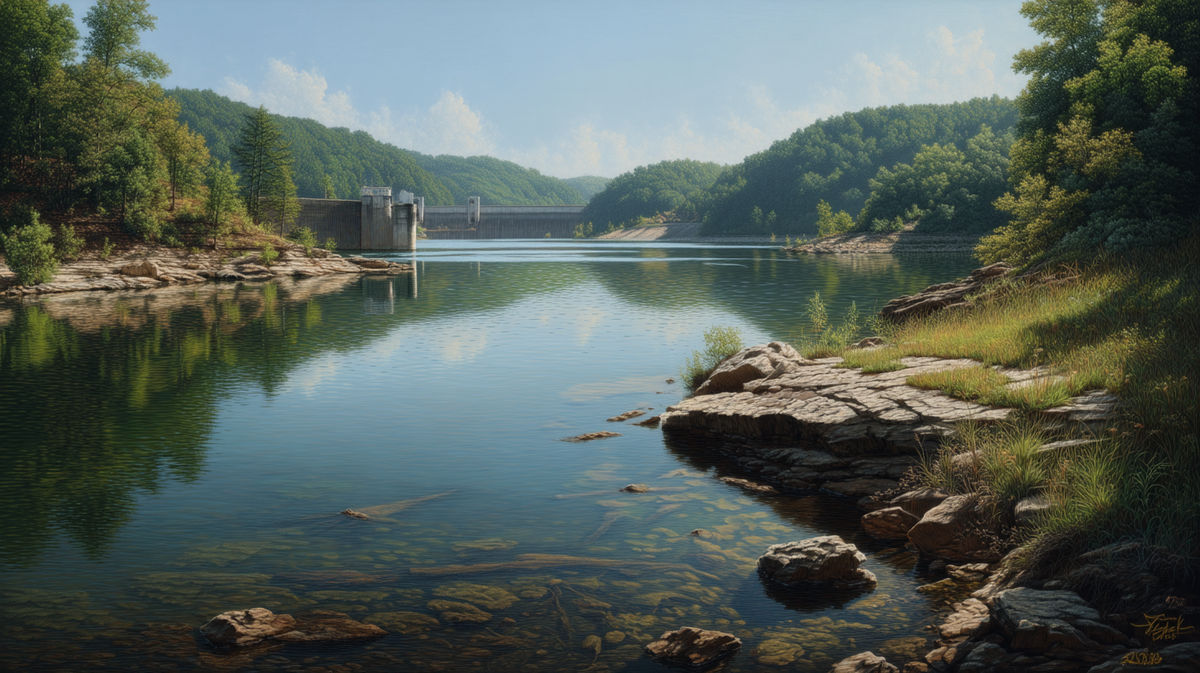
The Tennessee Valley Authority finished the Cherokee Dam in 1941 to make hydro power, tame floods, and store water. Those three goals still drive every water-level change you’ll see on the official table or map.
Things to Do on Cherokee Lake
Sun-soaked Saturdays usually start at one of the marinas-Black Oak or German Creek-where you can gas up, snag a breakfast burrito, and slide into 463 miles of shoreline.
When the pool’s near full, you’ll see pontoons towing kids on giant inflatables, wake-surfers carving flat water behind a new-school surf boat, and even a couple of small-sail regattas catching the afternoon breeze. Stick around after dark: many docks light up with live music and a rolling “dock-and-dine” vibe that feels more Caribbean than East Tennessee.
Anglers rave about the lake’s healthy bass and striper population, especially during steady generation releases out of the dam. Spring floods push baitfish into coves; by midsummer the fish follow shad schools out over deeper humps, and your sonar lights up like a Christmas tree.
Cooler weather? Locals switch to night crappie rigs or chase catfish below the spillway-there’s always a bite somewhere if you match your plan to the current elevation and weather pattern.
Not everything happens on the water. Hike the Overlook Trail at Panther Creek State Park for a drone-worthy view of Lake Cherokee, spread a picnic blanket near the dam where TVA posts a giant elevation gauge, or wander newly exposed sandbars during winter drawdown for arrowheads and old bottle finds.
Grab the free TVA recreation map, watch that daily level table, and you’ll discover a new adventure every time the lake changes by even an inch.
Understanding Water Level Changes
How the Tennessee Valley Authority (TVA) Manages Levels
Think of Cherokee as a seasonal storage battery. TVA fills it toward full pool in spring, then draws it down in autumn for flood pool space while spinning power through the turbines.
Seasonal Patterns: Summer vs. Winter Levels
Full pool sits at 1,073 feet above sea level; winter target drops to about 1,030, so the lake swings roughly 40 feet each year, sometimes an extra inch or two depending on weather.
Factors Affecting Fluctuations (Rainfall, Drought, Energy Needs)
Heavy rain, drought, or a big power schedule can change the current elevation quickly. TVA leans on decades of data and strict regulation guides to predict the schedule.
When Are Water Levels Highest and Lowest?
Typical Timeline of Annual Drawdown
Levels peak around late May and start a slow drop by mid-August, hitting winter pool near New Year’s Day unless unusual weather forces a faster change.
Peak Season for Water Activities
Memorial Day through Labor Day offers the safest boating window: deep ramps, long days, and predictable generation releases that keep the river tail cool.
How to Check Current Cherokee Lake Water Levels
TVA Lake Level Monitoring Tools
The TVA Lake Levels site and Lake Info app show real-time data, a two-day forecast, and a historical chart for quick comparison.
Best Mobile Apps and Websites
Skip the guesswork and check the TVA Lake Info app-it shows the current elevation, hourly generation releases, and a handy historical chart.
For bigger screens, CherokeeLake.info layers those numbers on an interactive map and emails you when water drops or rises more than an inch.
Anglers swear by the Navionics Boating app: overlay contour maps, then time your spots against TVA’s release schedule even if cell service fades. And keep the classic browser bookmark-TVA’s Lake Levels page-for daily storage notes and flood-control warnings.
How Water Levels Impact Recreation
Boating and Marina Access
When Cherokee Lake’s pool hovers near full, even deep-draft cruisers glide off the most remote ramps; drop the elevation below about 1,055 feet, and you’ll notice a few skinny launches at German Creek or Black Oak flashing temporary “low water” signs.
Marinas extend their floating walkways, but private docks can go dry fast, so keep an eye on the TVA update before you hitch the trailer. Mid-drawdown exposes stump fields that weren’t there last week-hug the marked channel and throttle back around points you don’t know by heart.
Fishing Conditions
A rising lake scatters baitfish into flooded brush, so spring bass pound spinnerbaits in water barely deep enough to wet your ankles. Once TVA starts daily generation releases, forage funnels toward river ledges, and stripers blitz the boils below the dam-prime time for live bait at dawn.
By winter’s lowest pool, crappie stack tight to standing timber and submerged roadbeds, while catfish patrol the deep holes at a predictable depth you can practically set a clock (or sonar) to.
Swimming and Shoreline Use
High water means sandy pockets disappear under a glassy surface that warms into the 80s by mid-July-perfect for a lazy float or a cannonball off a rental pontoon.
As the lake draws down, those same beaches grow by the foot, revealing red-clay flats that get slick after rain; pack water shoes if you’re visiting after Labor Day.
Remember: TVA can open turbines without warning, so stay clear of the dam and watch for sudden current changes signaled by horns.
Seasonal Tips for Lake Visitors
June through early August gives you the longest daylight, stable elevation, and the least debris-ideal for big-water sports and sunset cruises.
In shoulder seasons, plan your day around TVA’s generation schedule: paddleboards at daylight before the release, then chase the rolling boil for striper after lunch. Cold-weather explorers should dress for wind that whistles across half-empty coves, and always check the forecast-one heavy rain can bump the water level several inches overnight.
Impacts on Local Communities & Real Estate
Waterfront Property Considerations
Before you fall for those sunset views and vacation rental income, remember Cherokee Lake swings nearly 40 feet between full pool and winter drawdown. Walk any lot at the lowest winter elevation to be sure a future dock (and prop) will still have at least three feet of water. TVA must sign off on every pier, lift, and shoreline wall through its Section 26a permit process, so have the paperwork started early-buyers of homes for sale on Cherokee Reservoir expect it.
Prices shift by county: Jefferson City’s south-shore market shows a $599,900 median and roughly $247 per square foot with homes selling in around 39 days. Up in Grainger County, listings cool to a $435,000 median price and stay on the market closer to 80 days.
Check FEMA’s flood-risk map, too; houses sitting below the dam’s official flood-pool line may need extra insurance. Finally, double-check well depth and septic placement, because a sudden storage release can nudge groundwater levels overnight.
Do that homework and you’ll enjoy lakefront living year-round, not just when the pool is high.
Flooding Concerns and Drought Risks
Fall drawdown frees up enough storage to blunt a major flood, but severe drought can keep the lake fifteen feet low, stretching marina gangways and testing private wells.
How Locals Prepare for Water Level Changes
Marinas post daily readings, fishermen retune electronics to the new elevation, and shoreline owners slide lifts as the inch-by-inch change marches on.
Final Thoughts
Cherokee Lake water level knowledge keeps your boat floating, your fish biting, and your real-estate plans realistic. Grab reliable information, watch the weather, and you’ll enjoy the lake in any condition.
FAQ’s About Cherokee Lake, TN Water Levels
How much does the lake drop in winter?
Usually 30-40 feet between full pool and winter pool, depending on rainfall and power demand.
Where can I see the current elevation?
The TVA Lake Levels page and CherokeeLake.info give a real-time update and the exact foot-and-inch reading.
Can TVA predict when the lake hits full pool?
Yes, operating guides forecast the date, but extreme weather can change the schedule without warning.
Is it safe to boat near the dam during generation releases?
It’s legal but strong currents demand caution-follow TVA safety signage and wear a life jacket every time.
Does lower water hurt fish?
TVA maintains minimum flow to protect fish populations, and many anglers like the predictable winter pattern.


